The interactive map for Mungabareena Reserve in Albury is now functional on our website. You can view it here! Our series of interactive maps give you a more detailed look at our parks and reserves, with photos and points of interest able to be viewed online.
Mungabareena is a site of both natural and cultural significance. The reserve boasts several facilities including a boat ramp, picnic tables, and public toilets and is a popular day-use area with several access points to the Murray River for fishing and activities such as kayaking. You can also access the Hume and Hovell walking track from the reserve.

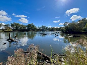
The interactive map takes you along a dirt walking track around the western side of the reserve, past a lagoon (which is a bit of a hidden gem)! Here you can enjoy the calm waters, admire the large trees including yellow box, and try your luck at spotting some bird life.
If you would like to contribute to maps of local walking trails, have a read about the Walking Maps Project.
N.B: The maps and the data utilised by them are intended to be free and open for anyone to use, download, and modify under a Creative Commons Licence 4.0.